1
/
of
2
Victoria Cooper Antique Prints
Plan of the Entrance of the Port of Bucarelli on the North West Coast of America, in 55'.15' of Latitude North & 136'.15' of Longitude West of Paris: Discovered in 1775 by the Spanish Schooner La Senora ... (S3-89)
Plan of the Entrance of the Port of Bucarelli on the North West Coast of America, in 55'.15' of Latitude North & 136'.15' of Longitude West of Paris: Discovered in 1775 by the Spanish Schooner La Senora ... (S3-89)
Regular price
$400.00 USD
Regular price
Sale price
$400.00 USD
Unit price
/
per
Couldn't load pickup availability
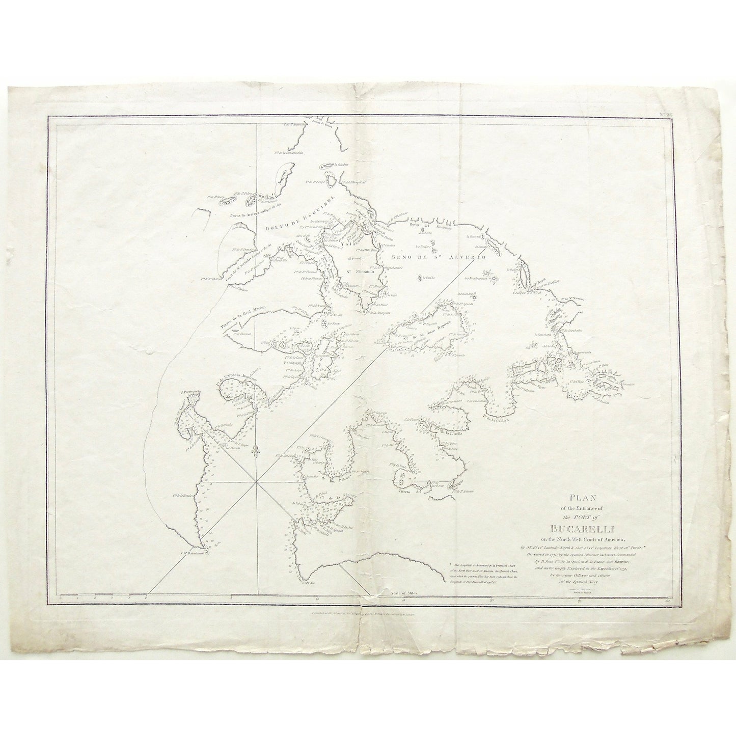
Plan of the Entrance of the Port of Bucarelli on the North West Coast of America, in 55'.15' of Latitude North & 136'.15' of Longitude West of Paris: Discovered in 1775 by the Spanish Schooner La Senora Commanded by D. Juan Feo. de la Quadra & D. Franco. Anto. Maurelle; and more amply Explored in the Expedition of 1779, by the same Officers and others of the Spanish Navy.
Upper Right: No. 26. Lower Center: Published as the Act directs Novr. 1st, 1798 by G. G. & J. Robinson, Paternoster Row, London. Lower Right: Neele Sc. Strand.
Author: La Pérouse, Jean-François de Galaup, comte de, (1741-1788)
Source / Publication: Charts And Plates To La Perouse's Voyage. Published as the Act directs Novr. 1st 1804
Publisher: G.G. & J. Robinson
Place of Publication: Paternoster Row, London
Date: November 1st, 1798
Date (Depicted): 1779
Plate Number: 26
Artist: La Pérouse, Jean-François de Galaup, comte de, (1741-1788)
Engraver: S. J. Neele
Paper Dimensions: 17 1/2 x 22 inches.
Platemark Dimensions: 15 7/8 x 20 1/4 inches.
Coordinates: 55'.15' of Latitude North & 136'.15' of Longitude West of Paris
Medium: Copper engraving
Language: English
Coloured: Black and white
Condition: The print is in good condition with some wear around the edges, particularly along the bottom where there is a tear in the print which goes just above the border of the image; as well as a few crease lines down the center of the print, as can be seen.
Keywords: Plan, Entrance, Port Bucarelli, Port, Bucarelli, North West, North West Coast, North West Coast of America, Coast, Coastal, 1775, Spanish, Spanish Schooner, Schooner, La Senora, Don Juan Feo de la Quadra, Don Franco Antonia Maurelle, Maurelle, de la Quadra, 1779, Spanish Navy, Sn. Feliz, Cape St. Feliz, Cape de la Portia, Punta de la Rosaria, Labandera, Isla de la, Indiada, Isleta, Aguada, Arroyo de la Cruz, Porto de la Santa Cruz, San José, Quembado, Arboleda, Ubi, Fula, el Barigon, los Dolores, Dolores, Remedios, Arroyo Blanco, Arucenas, Cangrejo, Romania, Maysil, Barca, Verde, Puerto del Refugio, Punta Gorda, La Bocas, San Antonio, Lira, Cipres, Flores, Estrella, Providencia, San Son, Empinado, Sosiego, Batan, las Lomas, Caldera, Santa Esigenia, Cabo Negro, Madre de Dios, Perlas, Viejo, San Sebastian, Canos del Nocadero, San Nicolao, Bagial, Los Mondragones, San Juan Baptista, Ysla de San Fernando, San Fernando, Seno de San Alverto, Ysla de San Ygnacio, Isla de San Ignacio, Canal de San Cristoval, Golfo de Esquibel, Anguilla, Canal de St. Nicholas, Bocas de Arriaga, Puerto de la Real Marina, El Puertezuelo, de la Asumcion, Mayoral, San Antonia, San Bartolomé, La Perousse, G.G. & J. Robinson, Paternoster Row, London 1798, Coastal chart, Expedition, Explored, Spanish Officers, Officers of the Spanish Navy, Officers, Alaska, Bucarelli Bay,
Price: US$400
Identification Number: S3-89
Share