1
/
of
2
Victoria Cooper Antique Prints
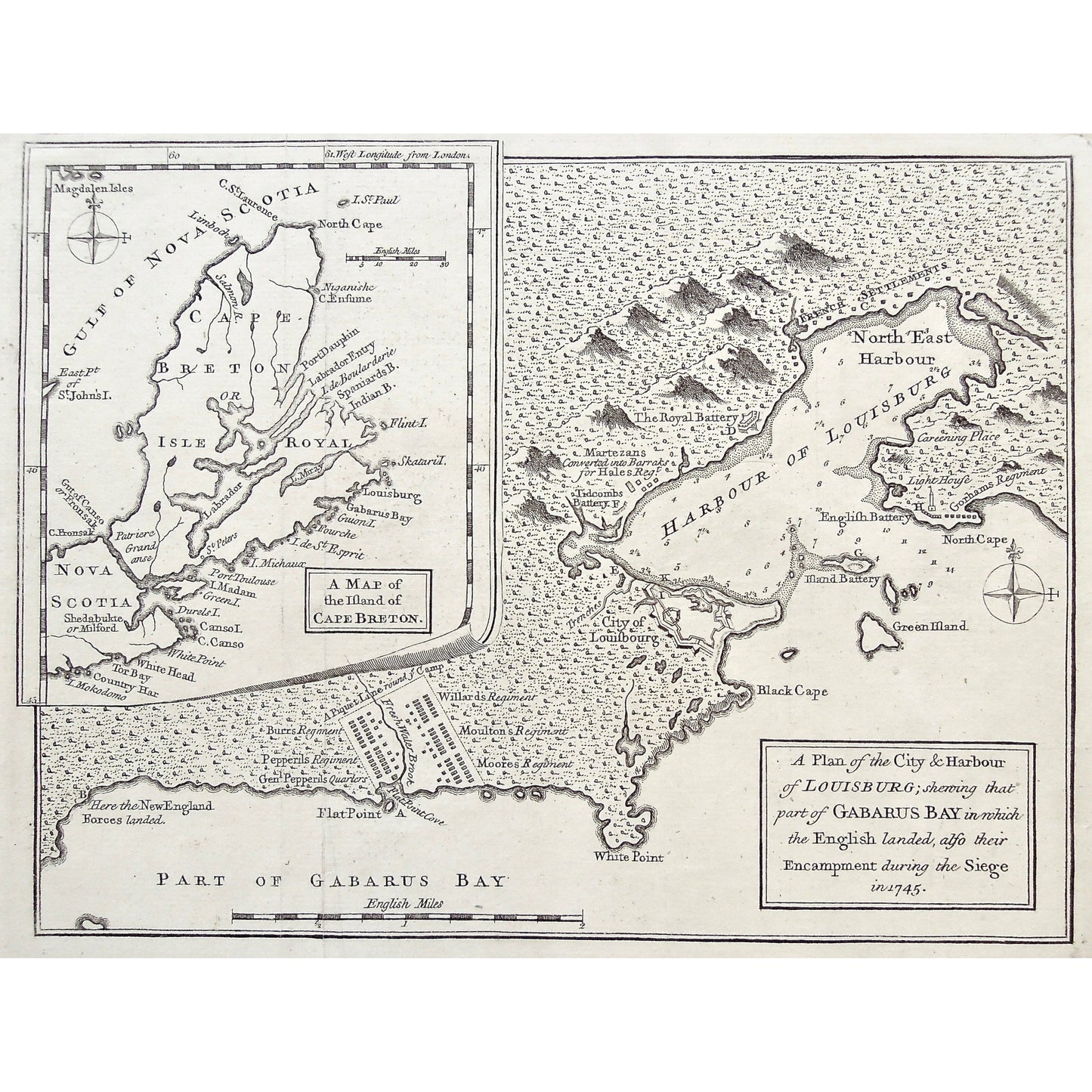
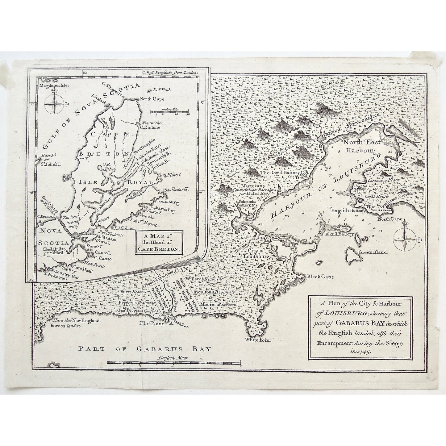
A Plan of the City & Harbour of Louisburg Shewing that Part of Gabarus Bay in Which the English Landed. also Their Encampment during the Siege in 1745. Inset: A Map of the Island of Cape Breton. (S3-72b)
A Plan of the City & Harbour of Louisburg Shewing that Part of Gabarus Bay in Which the English Landed. also Their Encampment during the Siege in 1745. Inset: A Map of the Island of Cape Breton. (S3-72b)
Regular price
$320.00 USD
Regular price
Sale price
$320.00 USD
Unit price
/
per
Couldn't load pickup availability
A Plan of the City & Harbour of Louisburg Shewing that Part of Gabarus Bay in Which the English Landed. also Their Encampment during the Siege in 1745. Inset: A Map of the Island of Cape Breton.
Source / Publication: The Gentleman's Magazine, and Historical Chronicle. Volume XXVII. For the Year M.DCC.LVIII. By Sylvanus Urban, Gent. (For March 1758.)
Publisher: D. Henry and R. Cave
Place of Publication: St. John's Gate, London
Date: 1758
Paper Dimensions: 8 1/4 x 10 1/4 inches.
Platemark Dimensions: 8 x 10 1/8 inches.
Medium: Copper Engraving
Language: English
Coloured: Black and white
Condition: The map is in great condition except there is some wear around the edges, particularly along the top of the crease lins along the left side of the map, and the on the bottom of the right side of the map, as can be seen.
References: http://babel.hathitrust.org/cgi/pt?id=mdp.39015020178284;view=thumb;seq=113
Keywords: Plan, City, Harbour, Louisbourg, Gabarus Bay, English landed, Encampment, Siege, 1745, New England Forces Landed, Flat Point, Burr's Regiment, Pepperil's Regiment, General Pepperil, Gen. Pepperil's Quarters, Piquet lane, Flat Point Cove, Fresh Water Brook, Willard's Regiment, Moulton's Regiment, Moore's Regiment, White Point, City of Louisbourg, Black Cape, Green Island, Island Battery, Battery Island, North Cape, English Battery, Harbour of Louisbourg, Trenches, Tidcombs Battery, Martezans, Barraks, Hale's Regiment, Royal Battery, French Settlements, North East Harbour, Careening Place, Lighthouse, Gorhams Regiment, Magdalen Islands, Magdalen Isles, Gulf of Nova Scotia, Nova Scotia, Island of Cape Breton, Map of Cape Breton, Cape Breton, Mokodomo, Country Har, Tor Bay, White Head, White Point, Cape Canso, Canso Island, Durels Island, Green Island, Isle Madam, Port Toulouse, St. Peters, Isle Michaux, Isle de St. Esprit, Fourche, Guion Island, Skatarid, Flint Island, Indian Bay, Spaniards Bay, Isle de Boularderie, Labrador Entry, Port Dauphin, Cape Ensime, Niganishe, Isle Royale, North Cape, Isle St. Paul, Cape St. Laurence, Laimboch, East Point of St. john's Island, Gut of Casano, Cape Fronsak, Patriere Grand anse, Shedabukte, Milford, Isle Mirar, Labrador, Map, Maps, Mapping, Chart, Charts, Charting, Vintage, Antique, Antique Map, Original, Rare, Rare Maps, Original Maps, Collector, Unique, Engraving, Copper engraving,
Price: US$320
Identification Number: S3-72b
Share